9 AM FRIDAY UPDATE:
As of 9 am Friday morning, the main line of rain and storms has pushed through the San Antonio area, and is now moving through our eastern counties.
Recommended Videos
While some of the storms found were strong, most of the activity in our viewing area remained sub-severe, but still produced heavy rainfall, lightning, and some gusty winds for the morning drive.
This activity will continue tracking through the eastern reaches of our area through the remainder of the morning, with clearing skies found into the afternoon.
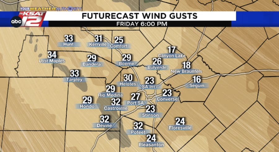
Winds will pick up for afternoon & evening plans, with wind gusts up to 30 mph expected near San Antonio.
Winds could gust upwards of 40 mph closer to the Rio Grande, prompting a Wind Advisory for the following counties, running through 7 pm:
- Val Verde, Edwards, Kinney, Maverick, Zavala, Dimmit
PREVIOUS UPDATE BELOW:
Another round of rain and storms is expected to push through South Central Texas Friday, likely making for some soggy spots for the AM commute and drive to school.
Here are the three main things you need to know (a full breakdown can be found below):
- Before sunrise Friday, thunderstorms will develop along the cold front out west, tracking eastward through the morning & into the first half of the afternoon.
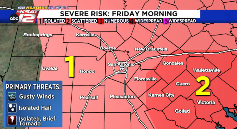
- An isolated strong/severe storm can’t be ruled out, with strong winds the biggest concern to monitor, followed by a low-end threat for isolated hail or a brief spin-up.
- Rain ends from west to east after the main line of storms passes, but winds will be gusty for any Friday evening plans.
Timing
As the cold front starts to work its way through West Texas Thursday night, scattered spots of light rain are expected to develop across parts of our area.
Coverage is then expected to increase across our western counties between 4 a.m. - 7 a.m. as the boundary approaches.
This main line of storms will continue tracking eastward, moving through the San Antonio area between 7 a.m. - 10 a.m.
After the storm activity moves through the central parts of the area, it’ll then push through our eastern counties between 10 a.m. - 1 p.m.
Expect clearing conditions into the afternoon hours once the front passes you by.
Severe Weather Possible
While it’s still on the lower end of the spectrum, the Storm Prediction Center gives a 1/5 to 2/5 risk for a few isolated strong & severe storms to develop within this activity.
- The primary concern in a stronger storm: Strong, gusty winds
- Lower concerns (but still not off the table): Isolated hail, brief spin-up tornado

We’ll also need to keep an eye on pockets of heavy rainfall as these storms track across the region.
As of Thursday morning, it’s looking like rainfall totals up to 0.5″ - 1″ will be possible, with localized higher amounts not out of the question under a few stronger storms.
KSAT’s Coverage
If needing to navigate around these storms Friday morning, plan on joining Your Weather Authority on our KSAT Weather Authority App for a live appcast and coverage. We’ll plan to jump on right after GMSA ends at 7 a.m.
- iPhone users: Download the KSAT Weather Authority app here.
- Android users: Download the KSAT Weather Authority app here.
Updates can also be found on our KSAT Weather social media pages.
- Follow KSAT Weather on Twitter
- Follow KSAT Weather on Facebook
Friday Night Plans
The vast majority of the area should be clear of the rain by Friday night activities and football games, but winds will be gusting up to 25 - 30 mph at times as drier air filters in behind the cold front.
Temperatures are slated to fall through the 70s for dinnertime plans and then into the 60s after the sun goes down.

In terms of our weekend forecast, it’ll feel like fall with lows in the 50s followed by highs in the 70s.
A full look at your forecast can always be found on our KSAT Weather Authority page.


