Close your eyes. Think of the Earth. You probably instantly see a blue marble with large patches of lush and green land and wispy clouds swirling around the globe. You know exactly what the Earth looks like.
It’s easy for us to take these images for granted. After all, we often see pictures and satellite images of our planet. As a meteorologist, I look at the Earth every single day, studying weather patterns.
Because we’re so familiar with these pictures of our planet, it’s hard to believe that we’ve only really had true images of the Earth for six decades. In fact, below is one of the first TV images of the Earth taken by the first weather satellite — TIROS 1.

TIROS 1 was launched into space on April 1, 1960, from Cape Canaveral. Equipped with two cameras, the first weather satellite transmitted the grainy black-and-white footage back to Earth. According to the National Air and Space Museum, President Dwight D. Eisenhower remarked, “The Earth doesn’t look so big when you see that curvature.”
TIROS 1 was only in operation for two and a half months. In June 1960, it experienced a power failure. As of 2024, it remains in orbit.
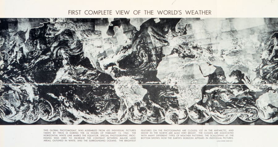
Four years later, a complete image of the world’s weather systems was first stitched together using pictures from another weather satellite, TIROS IX.

From there, it was off to the races. Now, 64 years later, modern GOES satellites see so much more than simple images of the Earth, such as global temperatures, lightning, dust, smoke, carbon dioxide levels, water vapor, infrared temperature, even individual, small clouds. That’s just naming a few!
Compare the first images of the Earth to one I grabbed from the internet just minutes ago, and you can clearly see just how far technology has advanced in 64 years:

Weather satellite images are vital to modern-day forecasting. They’ve helped the science of meteorology improve significantly. It’s fascinating to imagine what improvements will be made in the next 60 years!
Happy Earth Day, everyone!
- Read more from the meteorologists on the Whatever the Weather page
- Download KSAT's weather app for customized, accurate forecasts in San Antonio, South Texas or wherever you are
- Find the latest forecasts, radar and alerts on the KSAT Weather Authority page


