

Tuesday, September 10 marked the climatological ‘peak’ of hurricane season in the Atlantic basin due to a number of meteorological factors that support tropical cyclone development during this time of year.
What exactly are they? Let’s break it down.
Key Points
- June 1 marks the official start of the season, but mid-August through mid-October is the climatological window where the highest number of tropical cyclones are typically found.
- September 10 sits in this timeframe and is deemed the ‘peak’ of the Atlantic hurricane season as the environment turns more favorable for tropical development.
- Into the fall season, wind shear starts to increase again as overall air and water temperatures start to cool, typically leading to a lower number of tropical cyclones.

Sign up for the Whatever the Weather newsletter here.
Atlantic characteristics around this time of year
While frequent tropical waves come off the coast of Africa throughout the hurricane season, the environment in which they enter is more favorable for development during the mid-August to mid-October timeframe.
Wind shear
Wind shear, which is the change in wind speed and/or direction with height, is stronger earlier in the season. This acts against tropical development as wind speeds increase with height, inhibiting system growth.
Around this time of year, however, wind shear often decreases in the Atlantic basin, allowing more tropical systems to strengthen when combined with other favorable environmental conditions.
Ocean temperatures & moisture availability
Speaking of other favorable conditions, ocean temperatures continue to rise during the summer months in the Northern Hemisphere due to the natural tilt of the Earth towards the sun.
Warmer water temperatures act as fuel for tropical cyclone development along with plenty of moisture content (which isn’t hard to find over ocean waters!).
Why September 10?
According to NOAA, the exact date of September 10 is the day you are most likely to find a tropical cyclone somewhere in the Atlantic, statistically speaking. All of these factors are typically in sync at this time and make it easier for tropical systems to blossom and sustain themselves.
Sea surface temperatures generally keep warming into late September and early October, but wind shear often increases again into the fall season, which starts to work against tropical cyclone development.
Current activity in the tropics
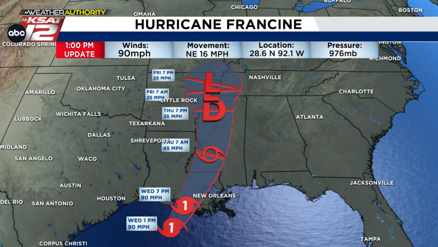
This year, the peak of hurricane season coincided with Hurricane Francine in the Gulf of Mexico.
Francine will not impact South Central Texas, but is expected to bring dangerous storm surge, high winds, and heavy rainfall to parts of Louisiana on Wednesday, likely making landfall by late afternoon and evening along the Louisiana Coast.
The storm will then work northward along the Mississippi River through the second half of the week, gradually weakening as it does so.
In other tropical news, Tropical Depression Seven formed Wednesday morning in the Eastern Atlantic. The system is gradually expected to move west over the next several days, likely strengthening into a tropical storm.
A few other disturbances have been flagged by the National Hurricane Center for potential tropical development, but odds are relatively low as of the latest update. We’ll monitor!
The next name on the 2024 Atlantic hurricane season list is Gordon, followed by Helene, Isaac, Joyce, and Kirk.

The Atlantic hurricane season officially runs through November 30.
Read more from the meteorologists on the Whatever the Weather page
Download KSAT's weather app for customized, accurate forecasts in San Antonio, South Texas or wherever you are
Find the latest forecasts, radar and alerts on the KSAT Weather Authority page