

It may be easy to think that Spring 2025 was not all that bad, especially because we got some very good rain at the end of May.
And while that rain was welcome, it wasn’t enough to offset periods of extreme heat experienced in March, April, and May.
When it’s all tallied up, Spring 2025 is officially the hottest spring on San Antonio’s weather record, with an average temperature of 74.8°.
Note that 5 of our hottest springs on record have occurred just within the last 20 years:

WHAT DO WE CONSIDER ‘SPRING’?
In meteorology, we consider spring to be the months of March, April, and May.
But what about the Spring Equinox and the Summer Solstice? Don’t they have something to do with the seasons? Yep! You can read more here.
SPRING 2025 IN A NUTSHELL
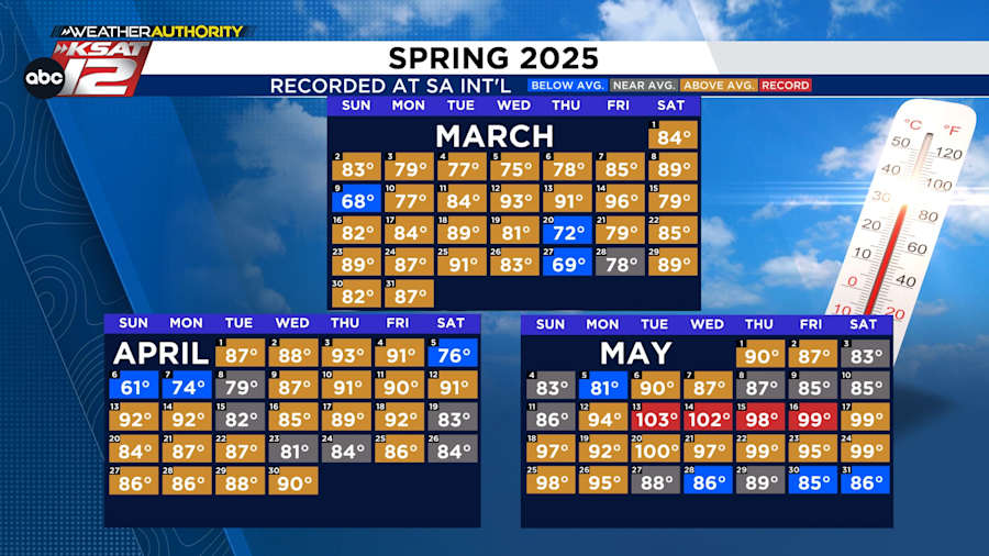
Throughout the 92 days of spring, only 10 days (11%) had cooler than average highs. Sixty-seven days (73%) featured highs above average, with a 4-day record-breaking heat streak from May 13 to May 16.
WHERE ARE WEATHER RECORDS KEPT?
At the San Antonio International Airport.
But why are they taken at the airport?
There are several reasons why San Antonio and the vast majority of other cities around the nation record official weather reports at an airfield:
- Airports offer a big, open space. There’s not much around them, so instrumentation and sensors can be out in the open and not much will interfere with them.
- There are other key factors that airports provide when it comes to taking measurements of temperatures, winds, cloud cover, dewpoints, air pressure, and rain totals:
- A flat surface for the most accurate measurements.
- Thermometers are be able to take measurements about 1.5 - 2 meters above the ground and away from high structures and buildings.
- Anemometers are able to be mounted about 10 meters above ground level and positioned away from high structures and buildings.
- Rain gauges are also able to be mounted about four to six feet above the ground, away from high structures and buildings, and also positioned far from any surface that could splash additional rain into the gauge.
HOW LONG HAVE SAN ANTONIO WEATHER RECORDS BEEN KEPT?
Official weather records date back to the 1880s. Here’s where the weather sites were before taken at the airport:
- When daily weather observations first started back in the 1880s, the first site was located in the Quadrangle at Fort Sam Houston.
- In 1891, recordings were then moved to the downtown area where the Weather Bureau was located. These buildings included the Dullnig Building, Alamo Insurance Building, Maverick Building, Hicks Building, a building with various names (313 E. Houston St), Alamo National Bank Building, and the Federal Building.
- Weather readings were then briefly moved to Stinson in 1941 before finding their permanent & current home at SA International in 1942.
For more information about these previous sites and the history of San Antonio’s weather reports, click here.
DOES THIS HAVE ANYTHING TO DO WITH CLIMATE CHANGE?
Yes, I know — it’s a hot-button topic — but climate change has played a role in our warmer weather.
This doesn’t mean that every single spring will be warmer than the next. In fact, as recently as 2019, our spring was cooler than average.
So, while times of cool (or even cold) weather will still exist for San Antonio, the weather on average will be warmer because of greenhouse gasses. There is abundant evidence that climate change causes Texas temperatures to average about two degrees warmer now than in the 20th century.
With that being said, the reason for our record spring is not all because of climate change. As usual, with hot-button issues, the answer falls somewhere in the middle. There ARE natural reasons for the above-average heat, and one of those reasons is because San Antonio and surrounding areas are known for spending long periods of time in drought.
When the weather is dry, it tends to be hotter. Sprinkle on the effects of greenhouse gasses and, voilà, you have record-breaking warmth.
South Central Texas tends to come out of droughts in a dramatic fashion.
After a dry stretch, it was the Flood of ‘98 that pulled us out of a late-90s drought. In 2015, it was the Blanco River floods that occurred after an extended La Niña drought.
History tells us that we should be prepared for flash flooding at some point over the next few years.

A collection of daily blog posts from the KSAT Weather Authority.
- Read more from the meteorologists on the Whatever the Weather page
- Download KSAT’s weather app for customized, accurate forecasts in San Antonio, South Texas or wherever you are
- Find the latest forecasts, radar and alerts on the KSAT Weather Authority page
